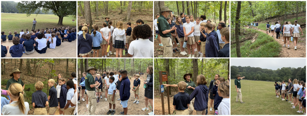
This week, all four 5th-grade classes spent the day at Kennesaw Mountain National Battlefield Park as part of their Civil War unit. I was there for the first half of the day and hiked the trails with one class and our guides, Steve and Steve. It was a day when history came off the page and onto the land, one stop at a time.
The trip took a unit that usually lives in books, maps, and timelines, and brought it to the ground. Students looked down lines of sight from the Confederate vantage point, crossed the field where Union soldiers stood, and stopped at the monuments that mark where men from Georgia, Alabama, Illinois, and Indiana fought, were wounded, and died. The day was built on a simple and powerful idea: some history is best understood by standing where it happened.
What I Observed
We started on the Pickett trail, and the guide began with an orientation and safety briefing. The trail signs are color-coded by side, Union and Confederate. There are marker signs about a quarter mile apart with coordinates, so anyone who is lost or hurt can say exactly where they are. Students also learned the poison ivy rhyme, “Leaves of three, leave it be. Fuzzy vine, not a friend of mine.” That was practical, memorable, and a small lesson in reading the landscape.
Then the history began, tied to the land at every step. At the trenches, the guide explained the picket line. Soldiers stationed forward would fall back to the foxholes and the main trenches behind them. Students saw that the Confederate defense was layered, with multiple lines, and that the trenches were fortified with wood from the mountain’s trees.
The guide then zoomed out to the big picture. The campaign for Atlanta started in Chattanooga, and it took two to three months of moving and fighting to get this far south. Atlanta mattered because it was where commerce and the rail lines met. The Union army followed the rail line because the railroad carried its supplies, and that same rail line can still be found near the park today. Sherman’s march was a series of smaller battles, and Kennesaw was where the Confederates chose to make a stand. The guide also called Kennesaw Mountain a monadnock, a lone mountain rising from flatter land, and connected it to Stone Mountain, which students already know.
Geography explained the strategy. The Confederates held the high ground and set up cannon batteries at the top of the mountain. Each cannon weighed about 3,000 pounds. Horses could not haul them up the slope, so the work required manpower and a block-and-tackle system. Students heard about the heat and the rain that came before the fighting, conditions they could imagine while standing in the Georgia woods themselves.
There was a strong human thread. Soldiers signed up at their local courthouse, so men from the same families and the same hometowns served together, and a single battle could take many of them at once. The guide gave the numbers: about 3,000 Union casualties and about 1,000 Confederate casualties. Students also learned that more soldiers died from disease than from battle. When medical supplies were cut off, dogwood bark was boiled into a tea to help reduce infection, and that turned the trees along the trail into part of the story.
The guide framed the Civil War as one of the first modern wars. Rifles and cannons changed the weaponry, and trains, telegraphs, and early modern medicine changed how war was fought and supported.
We crossed to the memorial field on the Union side, and Kathy Bruyn reminded our students to be respectful of what the place commemorates. Here, the story became specific and sobering. The main Union attack was at the Dead Angle, about three miles away, and the troops here were a diversion. From the picket line, the Confederates had a clear line of sight. About 300 Union soldiers from Indiana were killed, wounded, or captured. Students saw the Georgia, Alabama, Illinois, and Indiana monuments, and they finished by comparing two cannons: the green brass Confederate cannon and the iron Union cannon with the spiral inside the barrel.
Evidence of Practice
- Place-based learning: Every concept was attached to a spot students could see or stand in: the trenches, the woods, the memorial field.
- Zooming in and out: The guide moved between the big campaign (Chattanooga to Atlanta, the rail line, commerce) and the individual soldier (the courthouse sign-up, the hometown loss).
- Geography as explanation: High ground, line of sight, and a 3,000-pound cannon on a mountain made the strategy make sense instead of just being memorized.
- Concrete, memorable details: The block and tackle, the dogwood tea, the poison ivy rhyme, the coordinate signs. These are hooks students will retrieve later.
- Comparison: Brass vs. iron cannon, smooth vs. spiral barrel, Union vs. Confederate casualties, high ground vs. attacking uphill.
- Respect and reflection: Students were explicitly asked to treat the memorial field as a place of commemoration.
Strengths Observed
- History became physical. Students did not just read about high ground; they climbed it and looked down from it.
- The day connected cause and effect. Rail lines explained why Atlanta mattered, geography explained where the fighting happened, and supplies explained how armies moved.
- The human cost was clear and age-appropriate. Hometown enlistment, casualty numbers, and disease deaths helped students understand what the war meant for real families.
- Cross-curricular connections showed up naturally: science (the monadnock, dogwood bark as medicine, poison ivy), engineering (block and tackle), and technology (rifles, trains, telegraphs).
- Safety was taught as knowledge, not just rules. The coordinate signs and the plant rhyme gave students tools to take care of themselves.
- The tone at the memorial field modeled how we honor places where people lost their lives.
Wonderings
- The Civil War was described as one of the first modern wars. Which of those changes (rifles, trains, telegraphs, medicine) would students argue mattered most, and what evidence from the day would they use?
- How might the class return to the dogwood tea, the rail line, or the cannons weeks from now, as spaced retrieval, to see what stuck?
It takes a team
A day like this doesn’t happen by chance. Kate Burton led this effort from start to finish. She coordinated with the park, planned logistics for four classes, and ensured every student had a rich, safe, and meaningful experience. Thank you, Kate. Your thoughtful planning made the whole day possible.
Kate wasn’t alone. Thank you to the 5th-grade team, Kathy Bruyn, Vicki Eyles, Brian Toth, Becky Maas, Sammy Rigaud, Melissa Goodell, Jack Teske, and Jason Hammett, for being fully engaged all day. You hiked the trails, listened alongside students, asked good questions, kept the lines moving and the water bottles filled, and helped students connect what they saw to what they have been learning in class. Without a team, something like this is not possible.
And thank you to Steve and Steve, who brought the land and its history to life for our students.
How might we give more learning a place to stand?

